
Top Things To Do in Canyonlands National Park
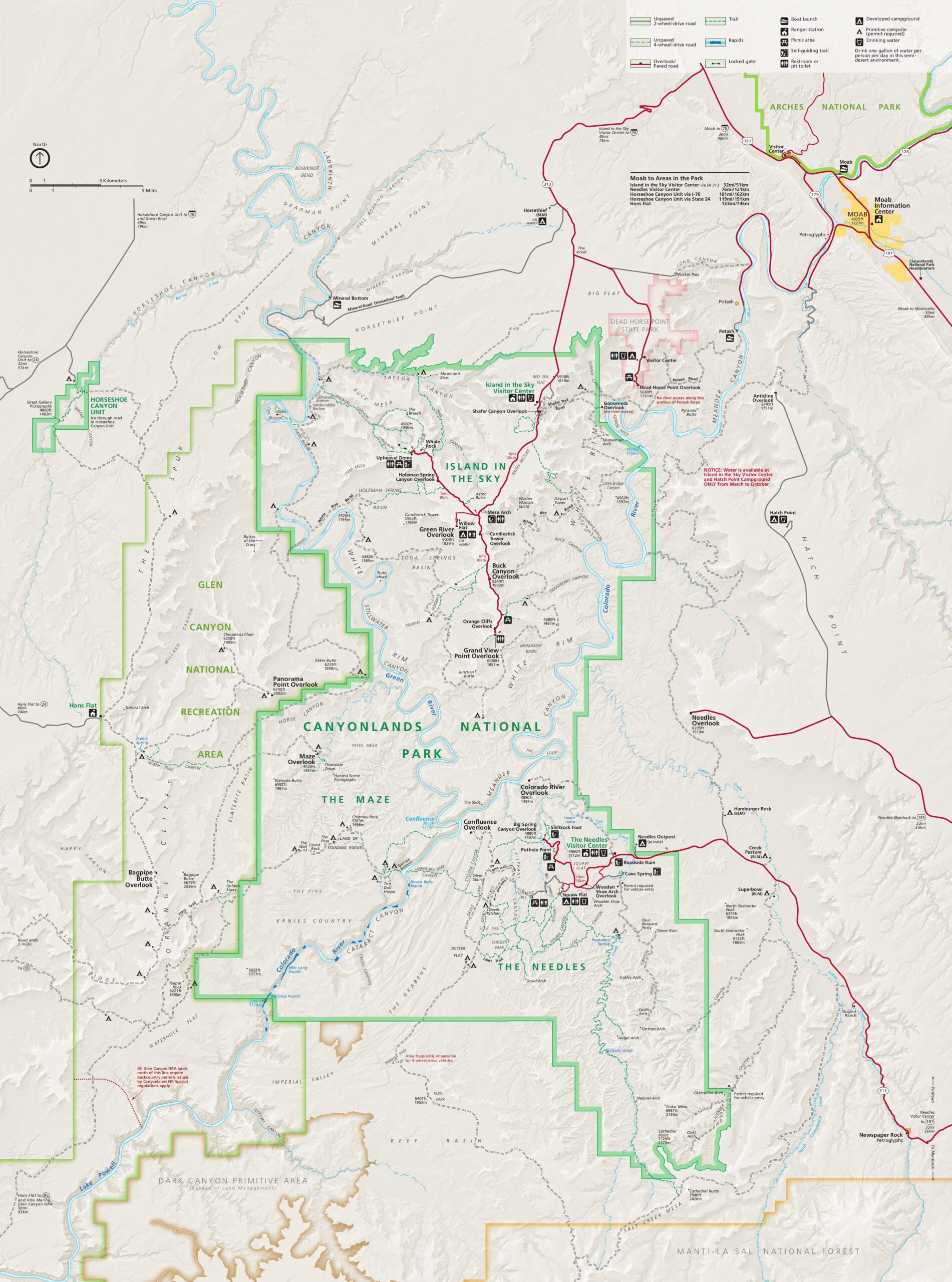
Canyonlands National Park is a wilderness of countless canyons and fantastically formed buttes carved by the Colorado River and its tributaries. Rivers divide the park into 4 districts: Island in the Sky, The Needles, The Maze, and the rivers themselves.
Canyonlands is located 30 miles north of Moab, 26 miles west of Arches National Park, and 241 miles south of Salt Lake City.
U.S. National Park
Canyonlands became a national park in 1964. It is one of the 63 U.S. National Parks.(A National Park is a scenic or historically important area of countryside protected by the federal government. Its purpose is the enjoyment of the general public or the preservation of land and wildlife).
At 527.5 square miles, Canyonlands is the largest of the 5 U.S. National Parks in Utah. The others are Arches, Bryce Canyon, Capitol Reef, and Zion.

Visit Canyonlands National Park
Canyonlands National Park is open 24 hours a day 365 days a year. No reservation is required for park entry. Passes can be purchased online or at the park entrance.
Admission is $30 for private vehicles, $25 for motorcycles, and $15 for individuals with no car. It is valid for 7 days. Or you can purchase a Southeast Utah Parks Pass for $55.00. It is valid for one year from the month of purchase. For more information, call the Canyonlands Visitor Information Line 435-719-2313.
Another option is to purchase a U.S. Park Pass for $80. It is valid for 12 months at over 2,000 federal recreation sites.

Things To Do in Canyonlands National Park
Canyonlands National Park features scenic drives, hiking trails, rock climbing, ranger programs, campgrounds, and picnic areas. You can helicopter over Canyonlands, or also fly over nearby Arches National Park in one trip. Note that ATVS are not allowed in Canyonlands.
Hiking in Canyonlands
Canyonlands has hundreds of miles of hiking trails which explore the park’s natural and cultural features. Both Island in the Sky and The Needles provide ample opportunities for short walks, day hikes and backpacking trips.
Due to its remoteness, the Maze is primarily a backpacking destination.

Suggested Itinerary – Island in the Sky
The National Park Service recommends the following itineraries in Island in the Sky. If you have….
1 Hour: Drive to Grand View Point and enjoy a broad view of the entire park. If time permits, visit Buck Canyon or Shafer Canyon overlooks along the way.
2 Hours: Visit Grand View Point and Green River Overlook, and hike the 0.5-mile-loop nature trail to Mesa Arch.
Half a day: Visit all of the above and enjoy many of the other short, mesa top nature trails to features like Whale Rock or Upheaval Dome. Attend a ranger-led program. Visitors with four-wheel-drive may consider returning to Moab via the Shafer Trail and Potash roads.

Full Day Itinerary – Island in the Sky
Full day: Hike several of the mesa top trails or one of the long, strenuous trails like Syncline or Murphy loops. With four-wheel-drive, explore the White Rim Road (permit required) as far as Musselman Arch or travel to the Colorado River via Lathrop.
Many days: Use the campground as a base camp and explore the district on foot or in a vehicle. Backpack into Taylor Canyon for a night, or to the Colorado River via Lathrop Canyon, or consider a multi-day, four-wheel-drive or mountain bike trip along the White Rim Road (permit required).

Suggested Itinerary – The Needles
The National Park Service recommends the following itineraries in The Needles section. If you have…
1 Hour: Hike any one of the short interpretive trails and drive to Big Spring Canyon Overlook to enjoy the view.
2 Hours: Drive the three-mile unpaved Elephant Hill access road for a distant view of The Needles. Hike one or two of the short interpretive trails.
Half a Day: In addition to enjoying the scenic drive, hikers can explore the Slickrock Trail or walk to the edge of Chesler Park for a closer look at The Needles. Visitors with four-wheel-drive vehicles might consider driving to the Colorado River Overlook. Spend some time at the visitor center learning about the area.

Full Day Itinerary – The Needles
Full Day: Hike one of the longer backcountry trails, or spend time exploring the four-wheel-drive roads, traveling up Horse Canyon to see the arches, or over Elephant Hill to the Confluence Overlook. (Permits required.)
Many Days: Use the campground as a base camp and explore some of the hiking trails. Backpackers could spend a night in Chesler Park or Lost Canyon. Visitors with four-wheel-drive could move their base camp into the backcountry, stay at Devils Kitchen or Peekaboo, and explore the area around those locations. (Permits are required for many backcountry visits).

Canyonland’s 3 Districts
The Colorado and Green Rivers divide Canyonlands National Park into 3 districts: Island in the Sky, The Needles, and The Maze.
Although they appear close on a map, there are no roads that link the 3 districts. Traveling between them requires 2-6 hours by car as there are few places to cross the rivers. Most people find it impractical to visit more than one area in a single trip.

1) Island in the Sky
The Island in the Sky mesa rests on sheer sandstone cliffs 1,000 feet above the surrounding terrain. It is the easiest area of Canyonlands to visit in a short period of time,
There are spectacular views from overlooks along the paved scenic drive, several hikes of varying length, and a moderate four-wheel-drive route called the White Rim Road.

Island in the Sky Visitor Center
The Island in the Sky Visitor Center has maps, a gift shop, backcountry permits, vault toilets, general information, and park rangers on duty. Their contact info is 435-259-4712.
The exhibits and orientation movie “Wilderness of Rock” are currently not open to the public. However, I talked the ranger on duty into letting me take pictures. (See below).
You can get drinking water inside the visitor center (during open hours) or outside the visitor center (24 hours a day year round). There is no water available at Willow Flat Campground.
Note that from January to early March the Island in the Sky Visitor Center is closed on Tuesdays and Wednesdays.

Shafer Canyon Overlook
The first overlook you will see after leaving the Island in the Sky Visitor Center is Shafer Canyon Overlook. I highly recommend that you take the short hike out to the rock ledge! You will be looking straight down at the canyons below.
And you will have a good view of the Shafer Trail, an unpaved backcountry road that descends 1,500 feet through a colorful, massive sandstone cliff. High-clearance 4WD vehicles with a low range gear are required. (ATVs are not permitted inside Canyonlands).
The trail was originally used by Native Americans to access resources on the mesa top. Then it was used by Mormon settlers to bring sheep and cattle to better foraging on the canyon floor in winter time. Then it was used by trucks moving uranium to nearby Moab.


Neck Spring Trail
Next you will pass the Neck Spring Trail, a 5.8 mile, 3-4 hour loop. The trail passes a historic corral on the mesa top. And it ends with panoramic views of Candlestick Tower, the Green River, and the White Rim Road.
Below the rim, fresh spring water emerges from the rock wall and gives life to surprisingly diverse plant communities.
Ranchers once developed these precious year round water sources for their livestock. Signs of their hard work are still visible today. Watering troughs, rusted tin cans, fencing, and other artifacts are easily observed from the trail.

Mesa Arch
Mesa Arch is a spectacular 27-foot arch clinging to the canyon rim. It frames views of the canyon far below, the La Sal Mountains, Buck Canyon, Washer Wiman Arch, and Monster Tower.
Mesa Arch has greeted every sunrise for millennia, and is a popular spot for sunrise photographers.
The trail from the parking lot to Mesa Arch is listed as a “half mile relatively easy trail.” I’m not a good hiker so I had to crawl at one place. And stop several times on the way back. But it was worth it!


Green River Overlook
Green River Overlook has the best views of the Green River, one of Canyonlands’ two mighty rivers: This southwest facing viewpoint offers a view of the river deep in its channel 1,300 feet below.
Visitors can also see features of The Maze district and the White Rim Road.

Aztec Butte Trail
The Aztec Butte Trail offers panoramic views and access to well preserved archaeological sites. It is a 2 mile hike that takes1.5-2 hours.
The difficult climb to the top of Aztec Butte traverses steep slopes, uneven terrain, drop offs, and ledges up to 3 feet high. Some scrambling on hands and knees may be required.
The trail follows a sandy wash, then splits. The eastern fork to your right ascends Aztec Butte for spectacular views.
The western fork on the left climbs the smaller butte then drops below the rim to two ancestral Puebloan granaries. Both trails require scrambling up slickrock and ledges.


Whale Rock
Whale Rock is a sandstone dome that looks like the back of a whale. To get to the top you take Whale Rock Trail, a one mile (round trip) one hour trail with steep drop-offs.
The trail begins with a quick, level walk across the desert. As it approaches the base of the butte, the trail climbs gradually on ledges and slopes finally becoming a short but steep ascent to the rock’s crest. The slickrock scramble onto the back of the whale makes this an especially fun hike for children
While I was talking pictures of Whale Rock from the parking lot, I met a local woman who was packing her gear. She had just got off work and was going to climb Whale Rock to watch the sun go down. She told me she packed a sleeping bag because when the sun goes down it gets cold.
Can you imagine going on a beautiful hike every day after work?? I would be so skinny! It made me want to move to Utah.


Upheaval Dome
Scientists think that Upheaval Dome might be the remnant of a meteorite impact. It cannot be seen from the road; you have to hike to get to it.
The Upheaval Dome Trail leads to 2 scenic overlooks. The First Overlook is a 1 mile, one hour round trip. And the Second Overlook is a 1.8 mile, 1.5 hours round-trip.
The trail also leads to a strenuous primitive route called the Syncline Loop Trail, which goes around the crater, but does not have a view of it.
The entire loop is 8.3 miles and has a 1,300 feet elevation change. It takes 5-7 hours to complete.


White Rim Road
The 100-mile White Rim Road loops around and below the Island in the Sky mesa top and provides expansive views of the surrounding area. Four-wheel-drive trips take 2-3 days, and mountain bike trips take 3-4 days.
Under favorable weather conditions, the White Rim Road is moderately difficult for high-clearance, four-wheel-drive vehicles.
The steep, exposed sections of the Shafer Trail, Lathrop Canyon Road, Murphy Hogback, Hardscrabble Hill, and the Mineral Bottom switchbacks make the White Rim loop a challenging mountain bike ride, and require extreme caution for both vehicles and bikes during periods of inclement weather.

Orange Cliffs Overlook
Orange Cliffs Overlook is named after the orange color of the mountains in the afternoon sun. Don’t forget to look down at the Green River, flowing toward its meeting with the Colorado River.

Grand View Point Overlook
Grand View Point is located at the southern end of the Island in the Sky Scenic Drive. If you only have one hour in Canyonlands, this is where the National Park Service recommends you spend it.
From Grand View Point you have a broad view of the entire park including the White Rim, features in The Maze and The Needles, and distant mountains.
A short, paved sidewalk leads to a spectacular viewpoint. From there you can hike an additional mile to a second viewpoint. Rangers often present geology talks at Grand View Point.


2) The Needles
The Needles section of Canyonlands National Park is a backcountry experience. You need to hike or four wheel drive to see the area’s attractions.
Bring your water bottle! The Needles Visitor Center does not sell water, but you can fill your water bottle at the center year round. And spring through fall you can get water at the nearby campground.

3) The Maze
Because of its isolation and challenging roads, The Maze is the lease visited area of Canyonlands National Park. It is a remote district requiring considerably more time and self-reliance to visit.
There is no running water in The Maze so you need to bring your own. There are no services, food, gas, trash collection, electricity for visitor use, or potable water in The Maze. The nearest communities with amenities are Hanksville (68 miles away) and Green River (86 miles away).
The remote Hans Flat (Maze) Ranger Station is normally open daily year round. It has a picnic table and vault toilet, and a small selection of books and maps for sale.

Horseshoe Canyon Unit
Horseshoe Canyon contains some of the most significant rock markings in North America. Located Northwest of The Maze, Horseshoe Canyon is a day-use area.
The Great Gallery (below) is the best known panel in Horseshoe Canyon. It includes well-preserved, life-sized figures. The hike to the Great Gallery is 7 miles (11.2 km) roundtrip, requiring 5 hours or more.


Green and Colorado Rivers
Flatwater trips on the Green or Colorado rivers – and whitewater trips in Cataract Canyon – are unique ways to experience the park that usually involve two or more days of boating.
This list of commercial guides that operate in Canyonlands, includes guided river trips.
Geology
The rock layers at Canyonlands National Park were formed over 300 million years ago. In contrast, the canyons were carved a mere 5 million years ago.
Canyonlands National Park preserves 337,598 acres of colorful canyons, mesas, buttes, fins, arches, and spires in the heart of southeast Utah’s high desert.
Geology Terms
* Canyon – A deep valley located between steep hills or mountains. Usually has a river flowing through it.
* Mesa – An isolated flat topped hill with steep sides, found in landscapes with horizontal strata (layers of rock).
* Butte – An isolated hill with steep sides and a flat top. Similar to a mesa, but narrower.
* Fin – A narrow, residual wall of hard sedimentary rock that remains standing after surrounding rock has been eroded away.
* Arch – A natural rock formation where an arch has formed with an opening underneath.
* Spire – A rock tower that has a uniform thickness throughout its height and tapers from the ground upward.


Wildlife in Canyonlands National Park
Canyonlands is bear country. Black bears wander into the park from nearby mountains, and have been spotted in The Needles, The Maze and along the Colorado River.
The National Park Service offers instructions on storing food in animal resistant containers and what to do if you see one. Hint! Play dead.

Native Americans in Canyonlands National Park
Humans first visited Canyonlands over 10,000 years ago. Nomadic groups of hunter-gatherers roamed throughout the southwest from 8,000 B.C. to 500 B.C.
Ancestral Puebloans farmed and lived in what is now Canyonlands. The descendants of these groups modern day Native American tribes, continue their relationship with this landscape.


Food, Lodging, and Gas in Canyonlands National Park
Unlike most national parks, there is no food, lodging, or gas available in Canyonlands. You will have to go to the nearby towns for these services.
Island in the Sky – Nearest services are in Moab; 32 miles from the Island in the Sky Visitor Center.
The Needles – Needles Outpost (open seasonally) is located just outside the park. It has camping, a general store, and showers. Other services closest to The Needles are in Monticello; 48 miles from The Needles Visitor Center.
The Maze – The nearest services to the Hans Flat Ranger Station are in Hanksville (61 miles away) or Green River (84 miles away).


